Entry · Ref B0IJX3JF
Comparing Drone Progress Tracking with Manual Site Photo Reporting
- Posted
- 2026-11-14
- Last amended
- 2026-11-14
- Account
- @aerialfieldnotes
Why Progress Monitoring Matters on a Construction Site
Every construction project relies on accurate progress monitoring. Stakeholders need to know whether work is on schedule, whether materials have been delivered, and whether any issues have emerged since the last visit. For years, the standard method has been manual site photo reporting: a person walks the site, takes photographs from a few fixed points, and uploads them to a shared folder or sends them in an email. That approach is familiar and straightforward. But as sites grow larger and timelines tighten, many teams are turning to drone progress tracking as a more thorough alternative.
Drones can capture a whole site in a single flight. Instead of a handful of ground-level images, you get a comprehensive set of aerial views that can be stitched into an orthomosaic - a single, scaled, georeferenced image of the entire area. This shift from manual snapshots to systematic aerial capture changes how you measure progress, spot problems, and communicate with the project team.
What Manual Site Photo Reporting Offers
Manual photo reporting is simple to set up. Anyone with a smartphone or a digital camera can walk the site and take pictures. No special equipment, no flight planning, no regulatory approvals. The photos are easy to label with the date and location, and they can be shared immediately via email or a messaging app. For small sites or short projects, this method can be perfectly adequate.
There are also practical limits. A person on the ground cannot see everything. High facades, rooftops, deep excavations, and distant corners of a large site are hard to capture from ground level. The number of photos is limited by time and accessibility. Two different people might take photos from slightly different positions, making it hard to compare the same spot week after week. And the images themselves are not georeferenced, so aligning them with a plan or a previous set of photos requires manual effort.
How Drone Progress Tracking Works
Drone progress tracking replaces the ad hoc approach with a repeatable, data-rich process. A drone flies a pre-planned route over the site on a scheduled flight date. The flight path is designed to cover the entire area with overlapping images, which are then processed into an orthomosaic and, in many cases, a 3D model. These outputs are georeferenced, meaning every pixel corresponds to a real-world coordinate. That makes it possible to measure distances, calculate volumes, and overlay the current state onto the design model or a previous capture.
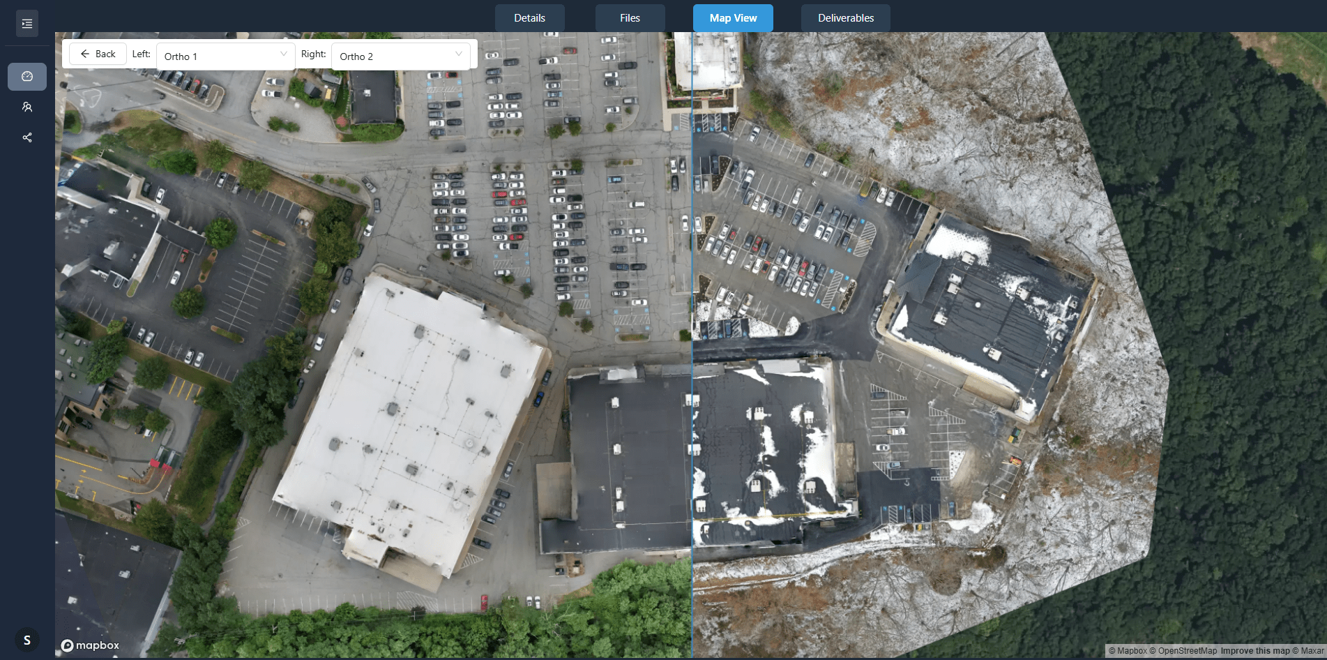
The key advantage is consistency. Because the flight path is saved and reused, each capture is taken from the same positions and at the same altitude. The result is a set of data that can be compared directly over time. Change detection becomes a matter of overlaying two orthomosaics and letting the software highlight differences. A manual process would require someone to scroll through hundreds of photos, trying to remember where each one was taken.
Comparing the Two Approaches
When you weigh drone progress tracking against manual site photo reporting, several factors come into play.
Coverage and Detail
A drone captures the entire site in one flight. You get a complete, bird's-eye view plus oblique angles if needed. Manual photos, no matter how many you take, will always have gaps. You cannot photograph the top of a crane or the far side of a stockpile from ground level. For projects where every corner matters - large commercial builds, infrastructure projects, or sites with complex geometry - drone coverage is hard to beat.
Time and Frequency
Walking a large site and taking a thorough set of photos can take hours. A drone flight covering the same area might take twenty minutes. That time saving makes it practical to capture data more often - weekly or even daily. Frequent captures mean you can spot delays or issues sooner. Manual reporting tends to happen less often because it takes more time and coordination.
Data Quality and Usability
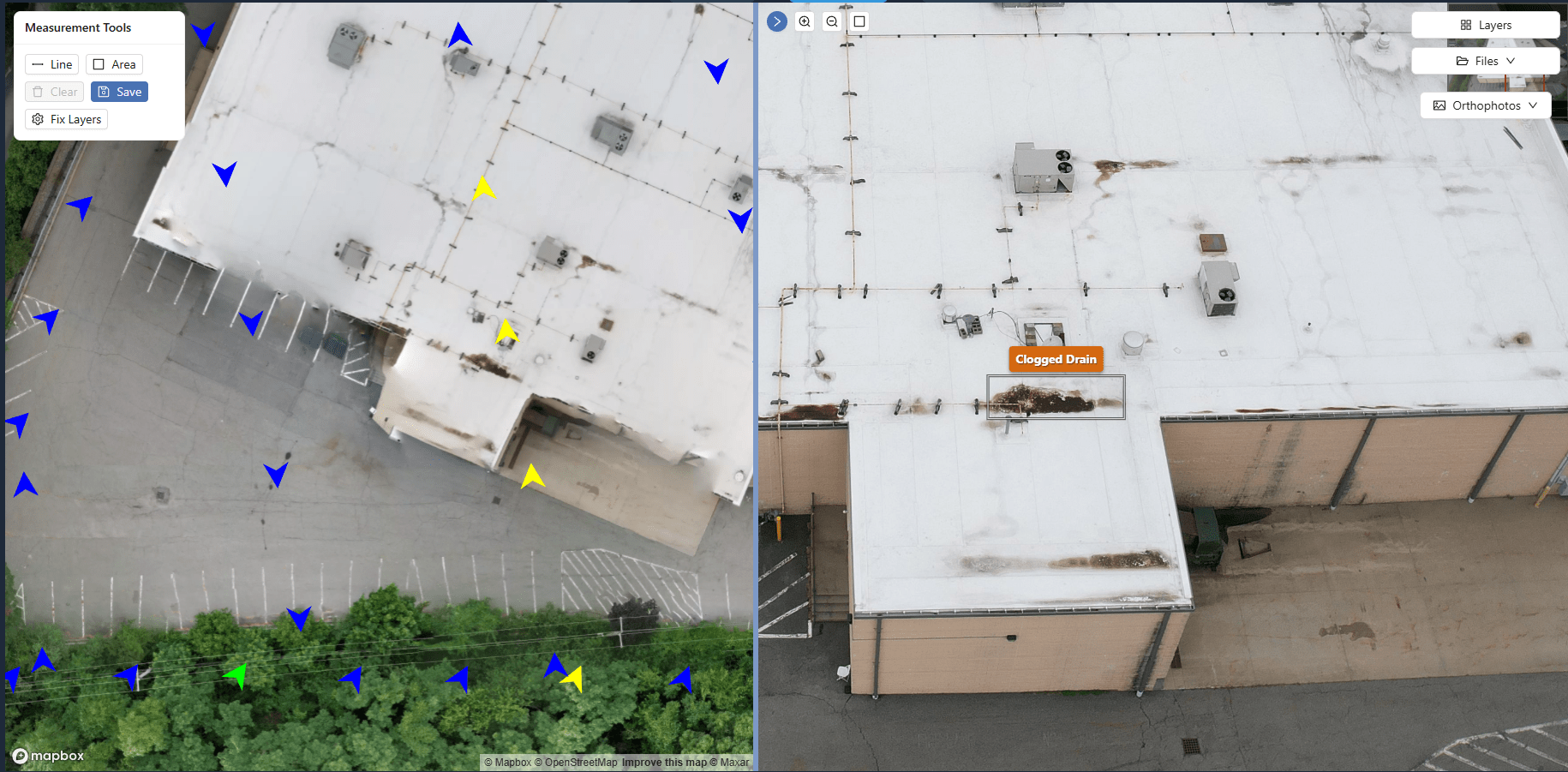
A manual photo is a single image. It shows what was in front of the camera at that moment. An orthomosaic or 3D model from a drone flight is a measurement-grade dataset. You can zoom in, measure, annotate, and compare it with other layers. You can use site annotation tools to mark up issues directly on the georeferenced image. The project team can view the data through a client portal rather than scrolling through an email thread. The quality of the information is higher, and it is easier to act on.
Hardware and Skill Requirements
Manual photo reporting needs no special equipment beyond a camera. Almost anyone on site can do it. Drone progress tracking requires a drone, a pilot, and compliance with aviation regulations. The data processing step also needs software to stitch the images into an orthomosaic. For teams that do not have these resources in-house, companies like National Drone Services can handle the capture and deliver the processed outputs. The trade-off is that you rely on an external provider or a trained pilot, but you gain a dataset that manual methods cannot produce.
Cost Considerations
Manual reporting is cheap in terms of equipment. The cost is mostly the time of the person taking the photos. Drone progress tracking involves an upfront investment in hardware, software, and training, or a per-project fee if you hire a provider. Over the life of a large project, the efficiency gains and the reduction in rework can offset the initial cost. For a small project lasting a few weeks, manual reporting may be the more economical choice.
When Each Approach Suits the Project
There is no single right answer. The best method depends on the size, duration, and complexity of the project, as well as the team's existing workflow.
Manual site photo reporting works well for small sites where a single person can capture everything from ground level. It suits projects that last only a few weeks, where the overhead of setting up a drone flight is not justified. It also fits teams that need a quick, informal record without the need for precise measurements or historical comparisons.
Drone progress tracking is better suited to medium and large sites, especially those with multiple structures, tall elements, or complex terrain. It is valuable for projects that run for months or years, where the ability to compare progress across many captures becomes a powerful tool. It is also the right choice when stakeholders need accurate, shareable data - for example, when reporting to investors, regulatory bodies, or the public.
Some teams use both. They rely on manual photos for daily logs and quick updates, and bring in a drone at key milestones to create a baseline or a monthly progress report. That hybrid approach gives them the flexibility of quick captures with the rigor of a full dataset when it matters most.
Making the Shift Work for Your Team
If you are considering moving from manual reporting to drone progress tracking, the first step is to define what you need from your progress data. If all you need is a visual record that work is happening, manual photos may still be enough. If you need to measure volumes, track subtle changes, or create a permanent record that can be revisited months later, drone data is worth the investment.
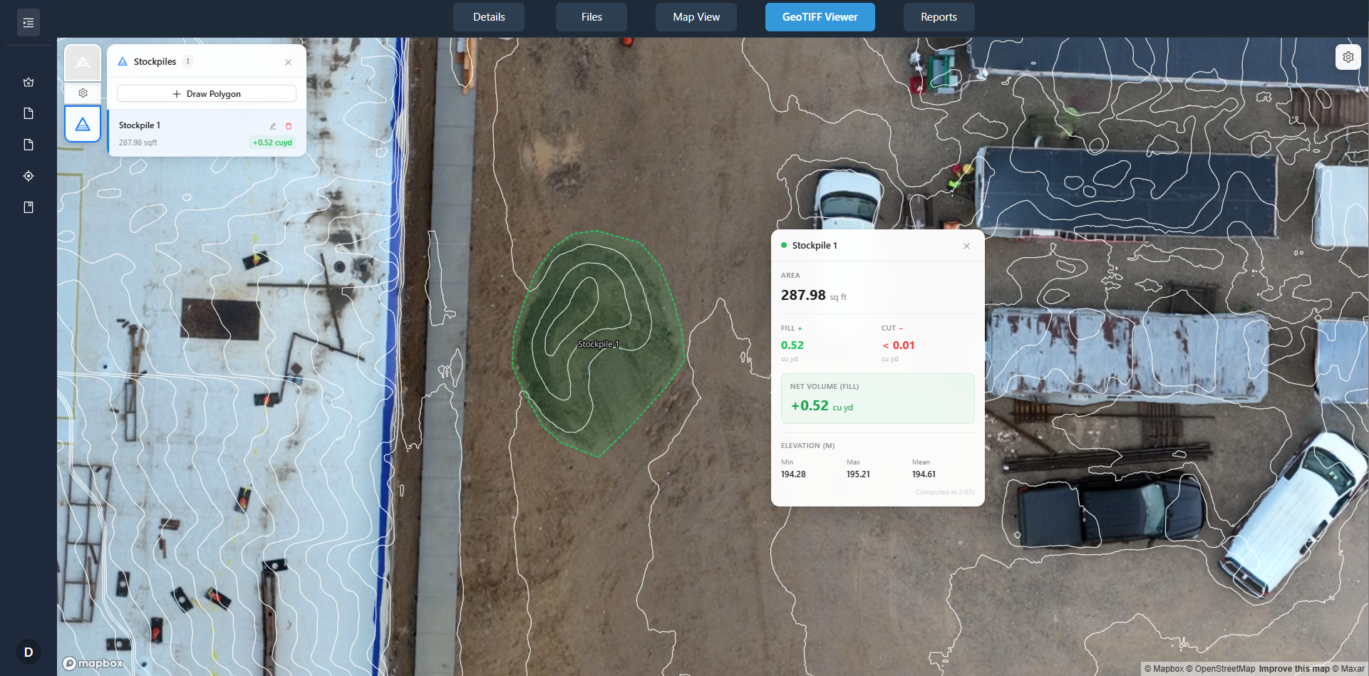
Next, think about the workflow. The raw output from a drone - hundreds of overlapping images - is not immediately useful. It needs to be processed into an orthomosaic, a digital surface model, or a 3D mesh. That processing step is where the value is created. Some teams do it in-house with photogrammetry software. Others prefer to receive the finished product from a provider. National Drone Services, for example, offers a drone data platform for processing, organizing, viewing, comparing, and delivering aerial imagery and mapping outputs through client portals. That means you do not have to manage the processing yourself; you get the final dataset ready for your project management team.
Finally, review your project timeline. Schedule drone flights at the same points in the project lifecycle where you would normally take manual progress photos. That could be at the start of each phase, after major milestones, or on a regular weekly or monthly schedule. Consistency is what makes the data comparable over time.
The Bottom Line
Both manual site photo reporting and drone progress tracking have their place. Manual reporting is simple, cheap, and easy to start. Drone tracking provides comprehensive, accurate, and comparable data that supports better decision-making. As projects become larger and more complex, the case for drone data grows stronger. The key is to match the method to the project's needs rather than assuming one is always better than the other.